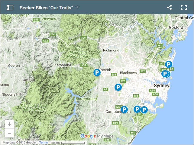
For such a big city Sydney has some great mountain biking, down South in the Royal National Park around Loftus, North around Manly Dam and over West in the Blue Mountains.
Please note inclusion here does not indicate a mountain bikers right to ride. Access is a problem in the area with just the shear number of mountain bikers trying to use trails being enough of a problem all on its own there are the added problems of much of the bush in and around Sydney being National Parks and therefore protected.
As always anywhere in the world if you treat the land, the flora and fauna and the people as you would expect people to treat you and yours most problems become significantly reduced.
Also note that most of Sydney’s trails dont cope at all with rain (noteable exceptions are Kentlyn and Menai) so please dont ride wet trails as it causes unnescessary damage.
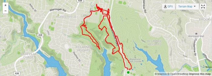
Manly Dam
16km NNE of Sydney CBD, 11km of difficult trail
The purpose built and waymarked 11km loop around Manly Dam is justifiably popular. Everyone from nervous intermediates to weekend warrior advanced riders will enjoy a lap or 3. There are some pretty big features and interesting technical challenges (all rollable) lurking around but all have obvious B lines and there are no nasty surprises.
Trail Heads include Manly Vale School (not at school start and finish times), Hydralics Lab or Seaforth Bowling Club
For trail status and other info click here
See our seperate blog post guide for detailed information (coming soon)
Gahnia and Serrata
16km N of Sydney CBD, 6.5km of difficult/severe trail
These are a new pair of trails built for NWPS just across the road from the Manly Dam loop. They are both very rocky and full of challenging intermediate to advanced features (all rollable). Neither one on their own is long enough for a decent stand alone ride but they make a good short ride when combined or better still when linked in with the Dam loop.
Trail head: Seaforth Bowling Club
See our seperate blog post guide for detailed information (coming soon) and for official information click here
Royal National Park & Loftus
32km SSE of Sydney CBD, up to 20km easy/moderate, up to 30km moderate/difficult/severe
The RNP, south of Sydney has some great mountain biking for riders of all levels but it can be a bit awkward to find and the official information available can be very confusing. For beginners Lady Carrington Drive is a beautiful, relatively smooth & wide, out and back track. The singletrack around Loftus provides good riding for riders from intermediate to advanced.
NB – Avoid all singletrack in the RNP after heavy rain and note that it takes a while to dry out. However the fire trail and management trails are (mostly) not a problem to ride when wet. To check official alerts on trail status etc click here
See our seperate blog post guide for detailed information (coming soon)
Trail Heads: Audely Visitors Centre for Lady Carrington Drive or Loftus Oval for singletrack.
CLICK HERE for all blog posts relating to the RNP & Loftus
Wylde, Western Sydney Parklands
50km W of Sydney CBD, 12km of moderate/difficult trails
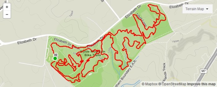
Wylde is a 12km, very manufactured, beginner/intermediate level loop in the Western Sydney Parklands. There are options to cut the lap into shorter 6km or 3km loops plus a very neat kids loop along with a pump track and other facilities at the carpark (inc water, toilets and bike wash!). Its a great place for introducing beginners while more experienced riders will have fun on the fast flowy (albeit very peadally) trails with fast berms and small tabletops.
The official website can be found here and check their facebook page here for trail status after rain.
Strava Segments: 12km full loop
Kentlyn
60km SW of Sydney CBD, typical ride is up to 20km of difficult trails with plenty of advanced options.
Kentlyn is a firm favourite with Sydney MTB Riders and this is justified with excellent technical and DH trails in a great setting. Its far enough out of town to allow a local trail builder culture to have thrived and my understanding is there is up to a total of 60km of trail in there now. You’ll find many of the local classics on strava like the Rock Trail (surprisingly fun flowy for something so technical and looking so twisty on the map), Crank It and Magic Carpet DH are great for starters.
Note – Kentlyns Trails deal with the rain much better than any others in the area and so are a great wet weather option when everything else is swamped.
Trail head is at Boronia Rd, Kentlyn
See our seperate blog post guide for detailed information (coming soon)
The Oaks Trail, Blue Mountains National Park
78km W of Sydney CBD, a one way trip of 27km on moderate/difficult trails
This Sydney Classic is a 27km one way, mainly downhill, ride between Woodford and Glenbrook through the stunning bush of the Blue Mountains National Park. Suitable for intermediate riders the first three quarters are on fire trail which can be fast and rough in places. While its predominatly down there are some short sharp climbs in there so dont expect freewheeling all the way. The last section is on fun single track. Beware for the sting in the tail up the road, ouch it hurts.
Normally done using the train for the shuttle our top tip is to do it on a Sunday and make the most of the maximum days charge of $2.50. Leave the car at home and use the train for the whole adventure.
The trail holds up well with rain and so is a good wet weather option but check the creek crossing at Glenbrook as it would be a show stopper in flood.
For official website info click here
ATTENTION – 02/09/2016 – The Glenbrook Single Mountain Bike Track will be closed due to potential asbestos contamination. No riders or walkers are permitted on this track during this closure. Woodford Oaks Fire Trail riders may continue down the Oaks fire trail to exit via Glenbrook. For more information, please contact NPWS Richmond (02)45882 400, Blue Mountains Heritage Centre (02)4787 8877 and click here for updates.
Menai
40km SW of Sydney CBD, a single lap is 19km on difficult trails
The new sanctioned trails at Menai are the solution created by local riders and Sutherland Shire Council to severe access problems in the area. Currently there is a 19km fig 8 xc style loop with plenty of interesting intermediate riding.
To find the trails park at ANSTO by the cafe, ride back to the main road and turn left toward the tip. Turn into the tip road and keep right at the fork to the chain link fence. Look for the track on the right past the gate and back onto the road. Ride down the road about 1km and you will come to a new pipe railing type fence (about 3 – 4 inch diameter)
The chain wire fence on your left will end here and run to the left. There is a sign marking the start of the trails .
Info on further building activity can be found here

